Description
Disclaimer: Copyright infringement is not intended.
Context
- An ancient river-carved landscape was discovered under the East Antarctic Ice Sheet.
- The research team used satellites and radar to see three river-formed areas roughly 215 miles from the edge of the ice sheet.
- If climate warming continues, the study authors claim, this region could get exposed for the first time in millions of years.
Details
- Using satellite observations and ice-penetrating radar, scientists are now getting a glimpse of Antarctica’s lost world.
- Researchers said on Tuesday they have detected buried under the continent’s ice sheet a vast ancient landscape, replete with valleys and ridges, apparently shaped by rivers before being engulfed by glaciation long ago.

About the Ancient Landscape
- Location: This landscape, located in East Antarctica’s Wilkes Land region bordering the Indian Ocean, covers an area roughly the size of Belgium or the U.S. state of Maryland.
- History: The landscape appears to date to at least 14 million years ago and perhaps beyond 34 million years ago, when Antarctica entered its deep freeze.
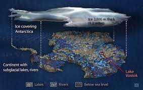
- The ice above the ancient landscape measures about 2.2-3 km thick.
- Topography: The landscape has been modified by different processes influenced by rivers, tectonics, and glaciation over a very long period of geological time.
Findings of the study
- At one time, there was evidence that Antarctica had tropical vegetation, including palm trees.
- Recently scientists have found a vast landscape by ancient rivers in Antarctica.
- This landscape is located in the Aurora-Schmidth basins, which are inland from the Denman and Totten glaciers.
- About 34 to 60 million years ago, a river flowed from the middle of the continent toward the coast.
- During this period, other continents like Australia and India were breaking away from Antarctica and the Gondwana supercontinent.
- According to the study, the river-carved landscape consists of three upland blocks separated by deep troughs, located only about 217 miles from the ice sheet edge.
- These blocks took their form before the ice covered the region, back when rivers flowed to a coastline formed during the breakup of the Gondwana supercontinent.
- As Antarctica gradually cooled, small glaciers started to form in the river valleys.
About Antarctica
Physical Geography
- The Antarctic Ice Sheet is the world's largest single chunk of ice. The ice surface expands substantially from approximately three million square kilometers (1.2 million square miles) at the end of summer to approximately 19 million square kilometers (7.3 million square miles) by winter.
- The Transantarctic Mountains, which divide Antarctica into eastern and western areas, have multiple high peaks.
- Without ice, Antarctica would form a massive peninsula and archipelago of mountainous islands known as Lesser Antarctica, as well as a single enormous continent around the size of Australia known as Greater Antarctica.
- Greater Antarctica, also known as East Antarctica, is made up of older igneous and metamorphic materials.
- Lesser Antarctica, sometimes known as West Antarctica, is composed of younger volcanic and sedimentary materials. It is part of the Pacific Ocean's Ring of Fire.
- Mount Erebus, on Antarctica's Ross Island, is the world's southernmost active volcano.
Climate and Waters
- Antarctica has an extremely cold, dry climate.
- The average winter temperature along Antarctica's coast ranges from -10° to -30° C (14° to -22° F).
- Coastal locations in the summer have temperatures that range from 0°C (32°F) to 9°C (48°F).
- The Antarctic region is crucial to global climate systems. It is an essential component of the Earth's thermal balance.
- Ice reflects more light than land or ocean surfaces. The vast Antarctic Ice Sheet reflects a significant amount of solar radiation away from the Earth's surface.
- The reflectance of the Earth's surface diminishes when global ice cover (ice sheets and glaciers) declines.
- This allows more incoming solar radiation to be absorbed by the Earth's surface, resulting in an unbalanced heat balance associated with global warming, the current phase of climate change.
The waters surrounding Antarctica are a key part of the “ocean conveyor belt,” a global system in which water circulates the globe based on density and currents.
- Antarctic Bottom Water, the chilly seas surrounding Antarctica, are so dense that they push up against the ocean floor.
- Warmer waters rise or upwell as a result of the Antarctic Bottom Water.
- Antarctic upwelling is so powerful that it aids in the movement of water around the entire planet. Strong winds that circumnavigate Antarctica contribute to this travel. Earth's waters would not flow in a balanced and effective manner without the assistance of the oceans surrounding Antarctica.
- The National Geographic Society designated the Antarctic Ocean as the Southern Ocean in 2021.

Flora and fauna
- Lichens, mosses, and terrestrial algae are among the few plant species found in Antarctica. The northern and coastal sections of Antarctica have more of this vegetation, while the interior has little to no vegetation.
- Thousands of species, including krill, feed on plankton. In the chilly Antarctic waters, fish and a wide diversity of marine mammals flourish.
- Antarctica has healthy populations of blue (Balaenoptera musculus), fin (Balaenoptera physalus), humpback (Megaptera novaeangliae), right, minke, sei (Balaenoptera borealis), and sperm whales (Physeter macrocephalus).
- The leopard seal (Hydrurga leptonyx) is a top predator in Antarctica. The leopard seal is one of the most vicious marine predators.
- The penguin is undoubtedly the most well-known animal in Antarctica. They've adapted to the frigid waters of the shore.
Indian Antarctic Program
- The Indian Antarctic Programme is managed by the National Centre for Polar and Ocean Research (NCPOR), which is part of the Ministry of Earth Sciences.
- The first Indian Antarctic expedition took place in 1981.
- After India ratified the Antarctic Treaty in 1983 and erected the Dakshin Gangotri Antarctic research station, which was replaced by the Maitri location in 1989, the initiative gained global acceptance.
- Bharati, a base composed of 134 shipping containers, was the most recently operational in
- As part of the initiative, India has launched 40 scientific expeditions to the Antarctic and is studying atmospheric, biological, earth, chemical, and pharmaceutical sciences.
|
PRACTICE QUESTION
Antarctica's ice sheets are considered a critical factor in global sea-level rise, and their melting has far-reaching implications for the world. Discuss the primary causes and consequences of Antarctica's ice melt. (250 words)
|


