IAS Gyan

Daily News Analysis

PIR PANJAL VALLEY

27th December, 2023 Geography

PIR PANJAL

Disclaimer: Copyright infringement not intended.

Context

  • One of the longest operations of this kind in the deep forests south of the Pir Panjal range in almost ten years is the fifteen-day Poonch encounter.

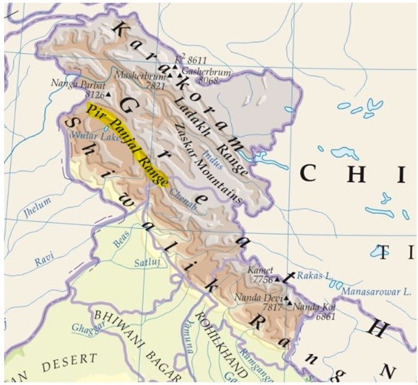
About Pir Panjal Valley

  • The Pir-Panjal Range is a collection of mountains in the Lesser Himalayan region that spans the Indian states of Himachal Pradesh and Jammu and Kashmir as well as Pakistan-administrated Kashmir.
  • It runs from east-southeast (ESE) to west-northwest (WNW).
  • The Dhauladhar and PirPanjal ranges are gradually elevated in the Himalayas.
  • The Lesser Himalayas' largest range is called PirPanjal.
  • It splits from the Himalayas close to the Sutlej River's bank, creating a rift between the Chenab and the Beas and Ravi rivers on opposite sides.
  • This range also contains the well-known
  • The area was formerly Kashmir's historical link to India and is connected to the Valley of Kashmir via the Mughal Road.
  • At the eastern extremity of the mountain range are two significant peaks, DeoTibba (6,001 m/19,688 ft) and Indrasan (6,221 m/20,410 ft).
  • This range is home to the Kashmiri hill resort of Gulmarg.
  • The Mughal Road links Rajouri and Poonch with the Kashmir valley by the PirPanjal Pass, also known as Peer Ki Gali.
  • At 3,490 metres (11,450 feet), it is the highest point on the Mughal Road and is located southwest of the Kashmir Valley.
  • The Jawahar Tunnel, which connects Banihal with Qazigund on the opposite side of the mountain, is 1.6 miles (2.5 km) long and passes through the Pir Panjal Mountain beneath the Banihal pass.

Passes in Pir Panjal

  • Pir Panjal Pass (3,480 m), the Bidil (4,270 m), Golabghar Pass (3,812 m) and Banihal Pass (2,835 m).
  • The Banihal Pass is used by the Jammu-Srinagar highway and Jammu-Baramula railway.
  • The Kishanganga, the Jhelum and the Chenab cut through the range.
  • Southeast of the Ravi, the Pir Panjal continues as Dhaola Dhar range, passing through Dalhousie, Dharmshala, and Shimla.

Important Valleys

  • Between the Pir Panjal and the Zaskar Range of the main Himalayas, lies the valley of Kashmir. (average elevation is 1,585 m above mean sea level)
  • The synclinal basin of the valley is floored with alluvial, lacustrine [lake deposits], fluvial [river action] and glacial deposits. {Fluvial Landforms, Glacial Landforms}
  • Jehlum River meanders through these deposits and cuts a deep gorge in Pir Panjal through which it drains. (Kashmir is like a basin with very few outlets)
  • In Himachal Pradesh there is Kangra Valley. It is a strike valley and extends from the foot of the Dhaola Dhar Range to the south of Beas.
  • On the other hand, the Kulu Valley in the upper course of the Ravi is transverse valley.

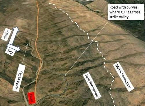
Strike valley vs. Transverse valley

  • A valley perpendicular to the slope or parallel to the ridge [also called as longitudinal valley]
  • In contrast, transverse streams cut valleys parallel to the slope (along the dip).

PRACTICE QUESTION

Between which ranges does the Kashmir Valley in the Himalayas lie?

A) Siwalik And Pir Panjal

B) Pir Panjal And Dhauldhar

C) Zanskar And Pir Panjal

D) Dhauldhar And Zanskar

Answer: C