Description
Disclaimer: Copyright infringement not intended.
Context
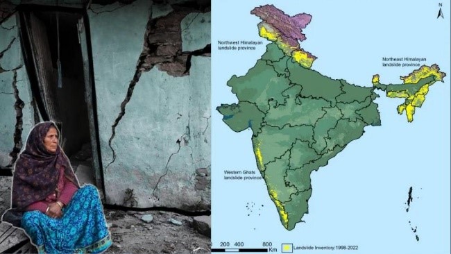
- With a steady rise in the number of extreme weather events, especially heavy rainfall capable of triggering landslides and floods, the Indian Space Research Organisation (ISRO) recently released the Landslide Atlas of India, a detailed guide identifying landslide hotspots in the country.
.jpeg)
What causes landslides?
- Landslides are natural disasters occurring mainly in mountainous terrains where there are conducive conditions of soil, rock, geology and slope.
- A sudden movement of rock, boulders, earth or debris down a slope is termed as a landslide.
- Natural causes that trigger it include heavy rainfall, earthquakes, snow-melting and undercutting of slopes due to flooding. Landslides can also be caused by anthropogenic activities such as excavation, cutting of hills and trees, excessive infrastructure development, and overgrazing by cattle.
- Considered among the most frequent natural disasters, landslides are extremely hazardous, posing a threat to human and animal lives, damaging property, roads and bridges, disrupting communication lines and snapping power lines.
- Some of the main factors that influence landslides are lithology, geological structures like faults, hill slopes, drainage, geomorphology, land use and land cover, soil texture and depth, and weathering of rocks. All these are factored in when a landslide susceptibility zone is earmarked for planning and making predictions.
- In India, rainfall-induced landslide events are more common.
How are landslides classified and mapped?
- Landslides are broadly classified based on the type of materials involved (rock, debris, soil, loose mud), type of movement of the material (fall, topple, slide, rotational slide or translational slide), and type of flow of the material. Another category is of landslides that spread laterally. Landslides mapped in the ISROatlas are mainly event-based and season-based.
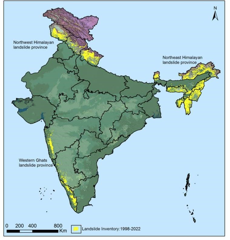
- ISRO’s National Remote Sensing Centre (NRSC), Hyderabad, has created a database of landslide-prone regions of India based on events during 1998 – 2022, primarily along the Himalayas and the Western Ghats. In addition to aerial images, high-resolution satellite images captured using cameras Indian Remote Sensing (IRS-1D) PAN + LISS-III, satellites ResourceSat-1 and 2, etc., were used to study the landslides over the past 25 years. The pan-India landslide database classifies landslides into – seasonal (2014, 2017 monsoon seasons), event-based and route-based (2000 – 2017).

How prone is India to landslides?
- India is considered among the top five landslide-prone countries globally, where at least one death per 100 sq km is reported in a year due to a landslide event. Rainfall variability pattern is the single biggest cause for landslides in the country, with the Himalayas and the Western Ghats remaining highly vulnerable.
- Excluding snow covered areas, approximately 6 per cent of the country’s geographical land area (0.42 million sq km) is prone to landslides. As many as 66.5 per cent of the landslides are reported from the North-western Himalayas, about 18.8 per cent from the North-eastern Himalayas, and about 14.7 per cent from the Western Ghats.
- Nearly half of the country’s landslide-prone area (0.18 sq km) is located in the states of Assam, Arunachal Pradesh, Sikkim, Meghalaya, Mizoram, Manipur, Tripura and Nagaland. Uttarakhand, Himachal Pradesh, Jammu and Kashmir cover 0.14 million sq km of the total landslide-prone areas, whereas Maharashtra, Goa, Karnataka, Kerala, and Tamil Nadu account for 0.09 million sq km. A relatively small area (0.01 million sq km) of the Araku region in Andhra Pradesh along the Eastern Ghats, too, reports landslide events.
- In the Western Ghats, despite fewer events, landslides were found to be making inhabitants significantly vulnerable to fatalities, especially in Kerala.
What does the landslide atlas suggest?
- Uttarakhand, Kerala, Jammu and Kashmir, Mizoram, Tripura, Nagaland and Arunachal Pradesh reported the highest number of landslides during 1998 – 2022.
- Mizoram topped the list, recording 12,385 landslide events in the past 25 years, of which 8,926 were recorded in 2017 alone. Likewise, 2,071 events of the total 2,132 landslides reported in Nagaland during this period occurred during the 2017 monsoon season. Manipur, too, showed a similar trend, wherein 4,559 out of 5,494 landslide events were experienced during the rainy season of 2017. Of the total 690, Tamil Nadu suffered 603 landslide events in 2018 alone.
- Among all these states, an alarming situation is emerging from Uttarakhand and Kerala.
- While Uttarakhand’s fragility was recently exposed during the land subsidence events reported from Joshimath since January, this Himalayan state has experienced the second highest number (11,219) of landslides since 1998, all events since occurring post 2000. The year-wise number of landslide events in the state is: 2003 (32), 2010 (307), 2012 (473), 2013 (6,610), 2017 (1), 2021 (329) and 2022 (1).
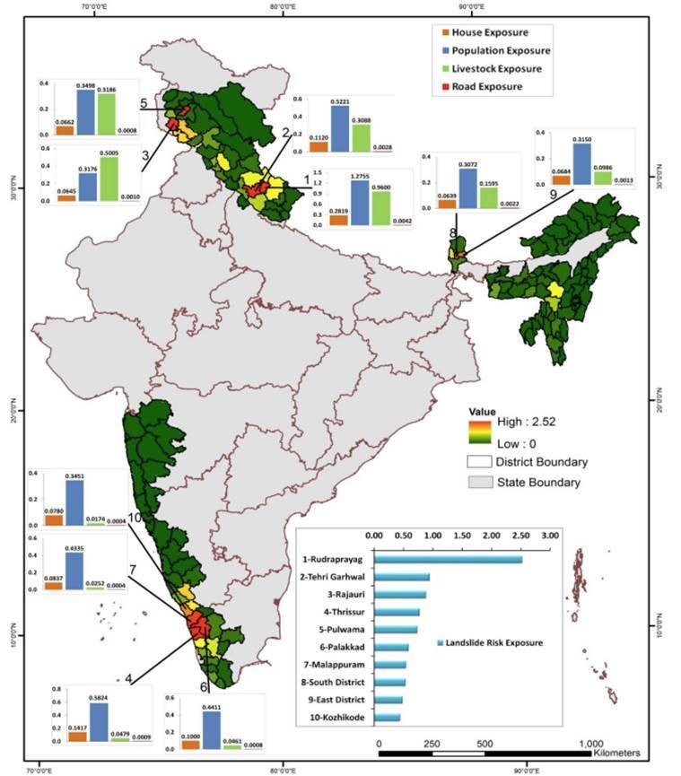
- The number of districts with the maximum landslide exposure are in Arunachal Pradesh (16), Kerala (14), Uttarakhand and Jammu and Kashmir (13 each), Himachal Pradesh, Assam and Maharashtra (11 each), Mizoram (8) and Nagaland (7).
- Kerala has been consistently reporting massive landslides since it suffered the century’s worst floods in 2018. The year-wise landslide events here are 2018 (5,191), 2019 (756), 2020 (9) and 2021 (29).
- From the events and images obtained, the NRSC ranked Rudraprayag in Uttarakhand at the top of 147 vulnerable districts. It has the highest landslide density in the country, along with having the highest exposure to total population and number of houses.

https://indianexpress.com/article/explained/explained-sci-tech/landslide-atlas-what-states-regions-are-most-vulnerable-8489965/


