Description
Disclaimer: Copyright infringement not intended.
Context
India's president has made a whistle stop tour of an island earmarked for multi-billion dollar development that experts warn could wipe out the indigenous tribe which calls it home.
Details
Great Nicobar Island:
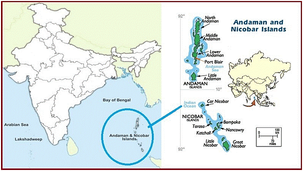
- The Andaman and Nicobar Islands is a cluster of about 836 islands in the eastern Bay of Bengal, the two groups of which are separated by the 150-km wide Ten Degree Channel.
- The Andaman Islands lie to the north of the channel, and the Nicobar Islands to the south.
- Great Nicobar is the southernmost island of the Nicobar Islands Archipelago, has an area of 910 sq km.
- The Great Nicobar Island lies between the Bay of Bengal and the Andaman Sea in a tectonically sensitive zone.
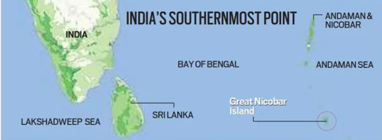
India’s southernmost point:
- Indira Point on the southern tip of Great Nicobar Island is India’s southernmost point, less than 150 km from the northernmost island of the Indonesian archipelago.

Protected area:
- Great Nicobar is home to two national parks, a biosphere reserve.
- National Parks: Campbell Bay National Park and Galathea National Park
- Biosphere Reserve: Great Nicobar Biosphere Reserve.
- Great Nicobar Island as one of the “Important Marine Turtle Habitats in India”. Beaches on either side of the Galathea River are the most important nesting sites in the northern Indian Ocean for the Leatherback turtle, the world’s largest marine turtle.
- The giant Leatherback is not the only species dotting this ecologically and culturally rich Island spanning over a little more than 900 sq. km, of which 850 sq. km is designated as a tribal reserve under the Andaman and Nicobar Protection of Aboriginal Tribes Regulation, 1956.
Inhabitants:
- The Mongoloid Shompen Tribe, about 200 in number, live in the forests of the biosphere reserve particularly along the rivers and streams.
- Another Mongoloid Tribe, Nicobarese, about 300 in number, used to live in settlements along the west coast.
Flora and fauna:
- It covers 1,03,870 hectares of unique and threatened tropical evergreen forest ecosystems, mountain ranges reaching almost 650 m above sea level, and coastal plains.
- It is home to a very rich ecosystem, including 650 species of angiosperms, ferns, gymnosperms, bryophytes, among others.
- In terms of fauna, there are over 1800 species, some of which are endemic to this area.
- Fourteen species of mammals, 71 species of birds, 26 species of reptiles, 10 species of amphibians, and 113 species of fish are found on the island, some of which are endangered.
Shompen Tribe
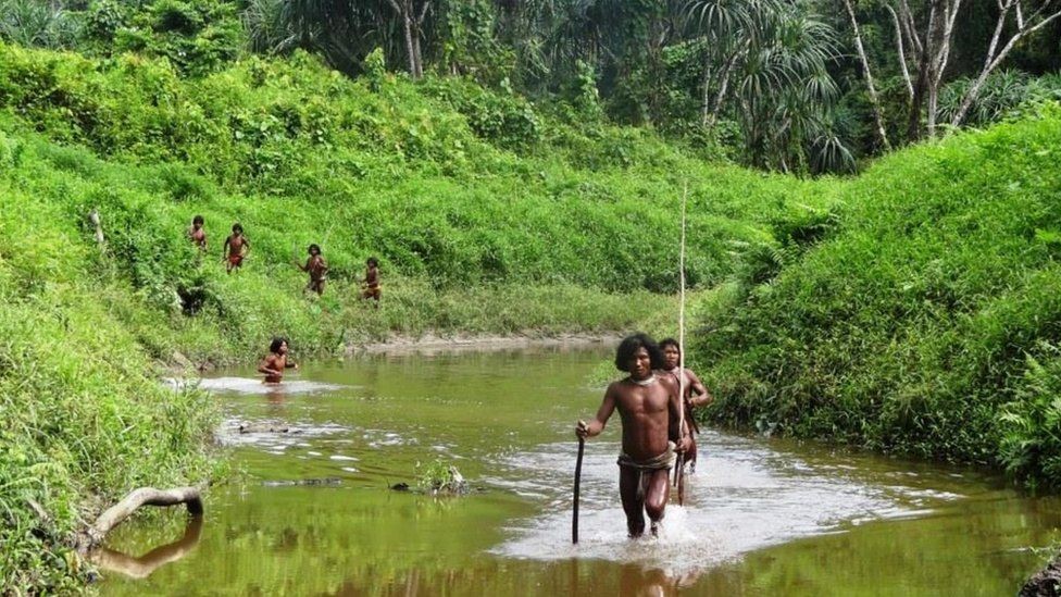
- The Shompen - who number between 100 and 400 people - are nomadic hunter gatherers who live in the island's rainforest.
- They are one of five "particularly vulnerable" tribes across the Nicobar and Andaman islands chain, but the only one on Great Nicobar.
- Though according to the Census (2011), the estimated population of Shompen is 229, the exact population of Shompen is unknown till today.
- Most of them are uncontacted, refusing all interactions with outsiders. Very few of the Shompen have ever had contact with the outside world.
- They collect a wide variety of forest plants, but their staple food is the pandanus fruit, which they call larop.
- Shompen speak their own language, which has many dialects. Members of one band do not understand the dialect of the other.
- Shompen have nuclear families comprising husband, wife, and their unmarried children.
- A Shompen family is controlled by the eldest male member, who controls all activities of the women and kids. Monogamy is the general rule, although polygamy is allowed too.
Threat and Concern
- Due to proposed Great Nicobar Development Plan, hectares of land on Great Nicobar Island will be reclaimed and may impact 1,700 people including many Shompens.
- Also this project will increase non-local population on the island which will affect the ethnicity of Shompens.
The “Holistic Development of Great Nicobar Island” project
- The Great Nicobar Island (GNI) is a mega project to be implemented at the southern end of the Andaman and Nicobar islands.
- A “greenfield city” has been proposed, including an International Container Transhipment Terminal (ICTT), a greenfield international airport, a power plant, and a township for the personnel who will implement the project.
- The port will be controlled by the Indian Navy, while the airport will have dual military-civilian functions and will cater to tourism as well. Roads, public transport, water supply and waste management facilities, and several hotels have been planned to cater to tourists.
Economic and strategic importance
- The government’s greater goal is to leverage the locational advantage of the island for economic and strategic reasons.
- Great Nicobar is equidistant from Colombo to the southwest and Port Klang and Singapore to the southeast.
- It is positioned close to the East-West international shipping corridor, through which a very large part of the world’s shipping trade passes.
- The proposed ICTT can potentially become a hub for cargo ships travelling on this route.
- As per the NITI Aayog report, the proposed port will allow Great Nicobar to participate in the regional and global maritime economy by becoming a major player in cargo trans-shipment.
- According to the government, expediting the project is of paramount national security and strategic importance.
- Increasing Chinese assertion in the Bay of Bengal and the Indo-Pacific has added great urgency to this imperative in recent years.

The concerns
- The proposed massive infrastructure development in an ecologically important and fragile region, including the felling of almost a million trees, has alarmed many environmentalists.
- The loss of tree cover will not only affect the flora and fauna on the island, it will also lead to increased runoff and sediment deposits in the ocean, impacting the coral reefs in the area, they have cautioned.
- Coral reefs, already under threat from warming oceans, are of enormous ecological importance. Environmentalists have also flagged the loss of mangroves on the island as a result of the development project.
- India has successfully translocated a coral reef from the Gulf of Mannar to the Gulf of Kutch earlier. The Zoological Survey of India is currently in the process of assessing how much of the reef will have to be relocated for the project. According to Government a conservation plan for the leatherback turtle is also being put in place.
- The project site is outside the eco-sensitive zones of Campbell Bay and Galathea National Park. The Centre has said that the development area is only a small percentage of the area of the island and its forest cover, and that 15 per cent of the development area itself will be green cover and open spaces.
|
PRACTICE QUESTION
Which one of the following pairs of islands is separated from each other by the ‘Ten Degree Channel’?
- Andaman and Nicobar
- Nicobar and Sumatra
- Maldives and Lakshadweep
- Sumatra and Java
Answer A
|


