Description
Disclaimer: Copyright infringement not intended.
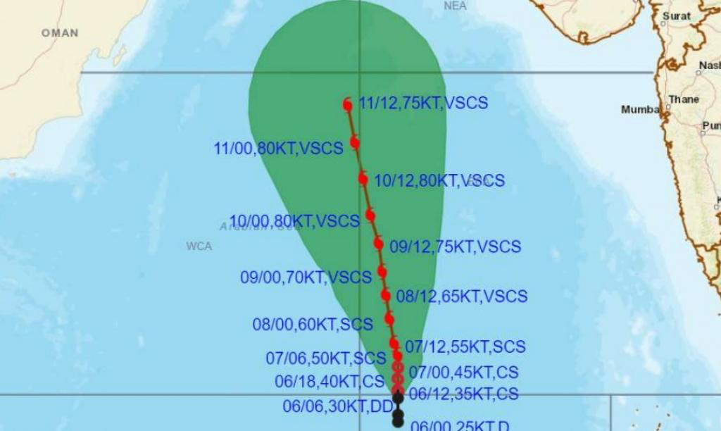
Context
- The development and intensification of a cyclonic storm named "Biporjoy" in the east-central and southeast Arabian Sea.
Details
Formation and Intensification:
- The India Meteorological Department (IMD) reports the development of cyclonic storm "Biporjoy" over the east-central and southeast Arabian Sea.
- The system intensified rapidly from a depression to a deep depression and further to a cyclonic storm on June 6, 2023.
Movement and Expected Intensity:
- In the last six hours, the deep depression moved northwards at a speed of 4 kmph.
- The cyclonic storm is forecasted to intensify into a severe cyclonic storm within the next 24 hours.
- The IMD predicts very severe cyclonic conditions with a wind speed of 115-125 kmph and gusts of 140 kmph on June 8.
- The severe cyclonic storm is expected to persist until June 11, with wind speeds estimated at 135-145 kmph and gusts of 160 kmph.
Potential Landfall and Uncertainty:
- Different weather forecast models provide contrasting predictions for the cyclone's track.
- The European Centre for Medium-Range Weather Forecasts (ECMWF) model suggests the system might move towards the Sindh province of Pakistan.
- The Global Forecast System (GFS) model indicates the possibility of landfall in Oman.
- The system's track and landfall location are still uncertain, and further monitoring is required to make accurate predictions.
Impact on Pakistan and Oman:
- The cyclonic storm is currently located 1,420 km south of Karachi, according to the Pakistan Meteorological Department (PMD).
- PMD states that no coastal areas of Pakistan are currently under threat, and the situation is being monitored.
- Oman has experienced numerous landfall events with tropical cyclones in the past, resulting in extreme winds, storm surges, and flash floods.
Climate Change Connection:
- Rising sea surface temperatures in the Arabian Sea, influenced by climate change, contribute to the formation of intense cyclones.
- Sea surface temperatures of 30-32 degrees Celsius, above the climatological mean, are favorable for cyclone development.
- The cyclonic system may delay the arrival and progress of the southwest monsoon in India due to moisture diversion.
Impact on Monsoon and Climate Patterns:
- The cyclonic system hinders monsoon winds and moisture flow, potentially causing a delay in the onset and progression of the southwest monsoon in India.
- Long-term Indian Ocean warming and the development of El Nino could weaken the monsoon, affecting the overall climate patterns in the region.
|
PRACTICE QUESTION
Q. Analyze the relationship between El Nino and Tropical Cyclones. Discuss their impacts 250. (250 words)
|

https://www.downtoearth.org.in/news/climate-change/biporjoy-cyclonic-storm-develops-over-arabian-sea-could-make-landfall-in-pakistan-or-oman-89858


