Description
Copyright infringement not intended
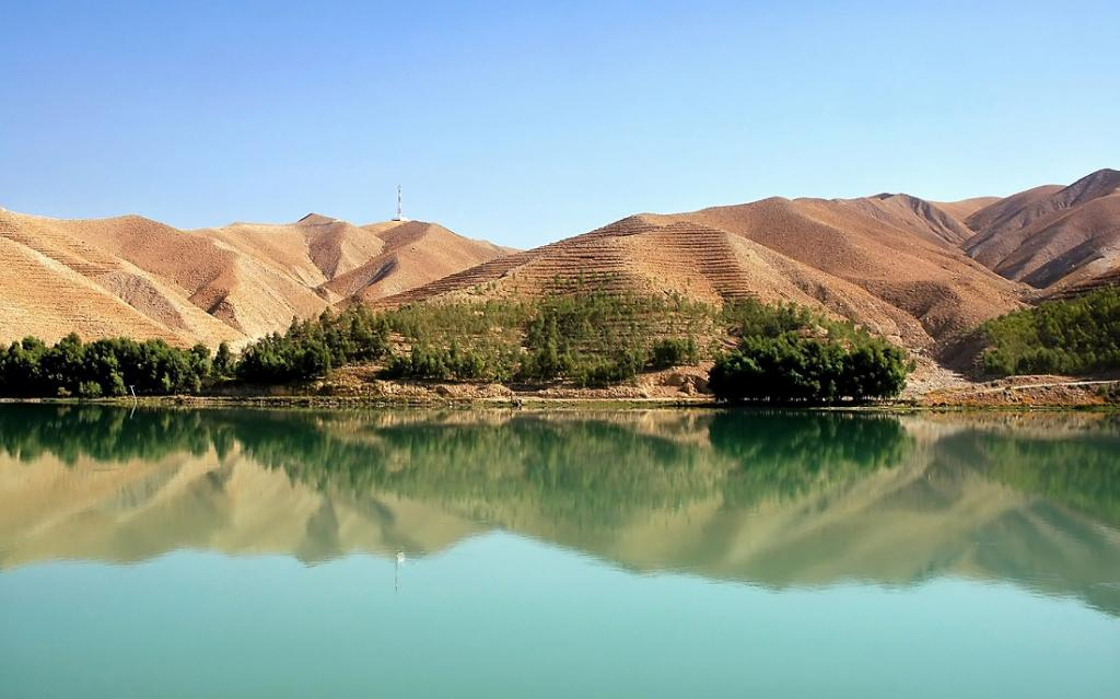
Picture Courtesy: https://www.downtoearth.org.in/news/water/amu-darya-and-kabul-river-basins-major-sources-of-water-for-afghanistan-study-95861
Context: The study on water resources in Afghanistan presents important insights into the country's hydrology, highlighting key river basins, water sources, and the challenges posed by water stress and climate change.
River Basins and Water Sources
- Afghanistan is divided into five major river basins: Harirod-Murghab (HMRB), Helmand (HRB), Kabul (KRB), Northern (NRB), and Panj-Amu (PARB).
- The Panj-Amu (PARB) mainly formed by the Amu Darya (Oxus) River, is Afghanistan's second-largest basin, covering 14.3% of the country's area.
- The HRB is the largest basin, with the Helmand River being the longest and biggest river in southwest Afghanistan.
- The Kabul River Basin (KRB) is significant and covers 11% of Afghanistan, with water production both within the country and into Pakistan.
Water Yield and Distribution
- The Panj-Amu Basin (PARB) contributes a substantial amount of water (42.7 BCM), with significant flow from Tajikistan due to glacier melting.
- The Helmand River Basin (HRB) has a mean annual water yield of about 11.7 BCM.
- Other basins like HMRB, NRB, and KRB also contribute varying amounts of water, supporting irrigation and domestic use.
Factors Influencing Water Availability
- Higher precipitation and lower evapotranspiration losses contribute to higher water yields in the Kabul and Panj-Amu Basins compared to other basins.
- Water availability is highest during spring months, highlighting seasonal variations that necessitate alternative water sources during dry periods.
Water Stress and Climate Change
- Afghanistan faces extreme water stress, compounded by recurrent droughts, population growth, and climate change impacts.
- The study highlights the acute water scarcity in Central Asia, affecting a significant portion of the population and exacerbating regional water shortages.

Implications for Water Resource Management
- The Study emphasizes the importance of long-term planning for water resources and agricultural development.
- Understanding external water sources (28.6 BCM generated outside Afghanistan) is crucial for sustainable water management and addressing water scarcity.
- Climate change poses significant challenges to water availability and requires adaptive strategies to mitigate impacts on water resources.
Future Water Demand and Sustainability
- With a growing population, water demand in Afghanistan is expected to increase, necessitating sustainable water management practices.
- Climate change will continue to impact water availability globally, highlighting the importance of adaptive measures and international cooperation to address water-related challenges.
|
The study provides valuable insights into Afghanistan's water resources, highlighting the need for integrated water resource management strategies to ensure water security, agricultural sustainability, and resilience in the face of climate change and growing water demand.
|
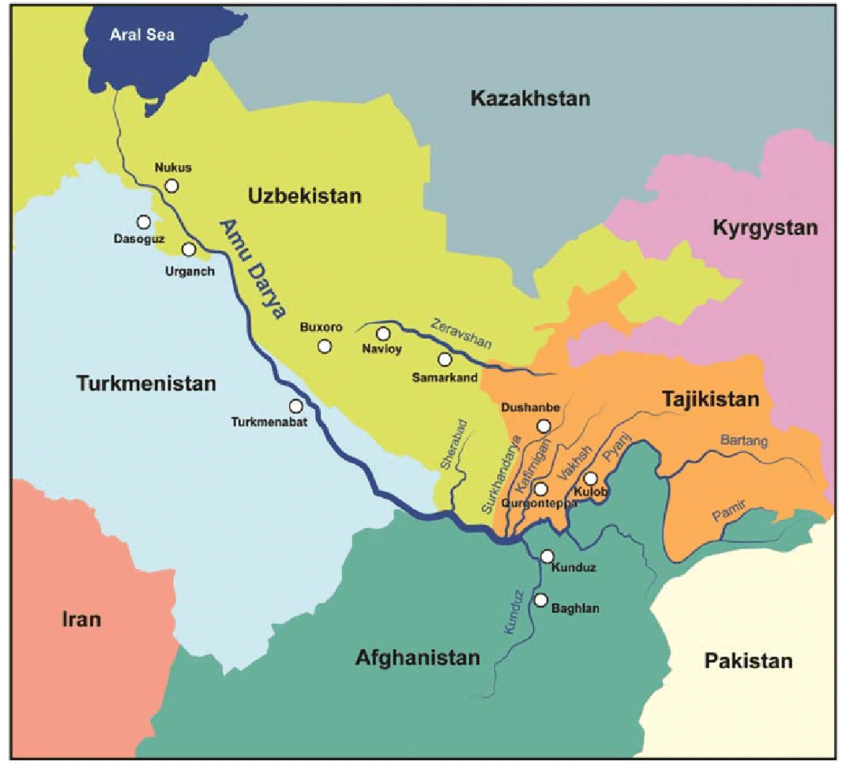
About Amu Darya
- The Amu Darya, historically known as the Oxus, is a significant river in Central Asia with a rich history and critical importance for the region's water resources.
Origin and Course
- The Amu Darya originates in the Pamir Mountains, north of the Hindu Kush.
- It is formed by the confluence of the Vakhsh and Panj rivers at the Tigrovaya Balka Nature Reserve on the Afghanistan-Tajikistan border. From there, the river flows northwestwards through Tajikistan, Turkmenistan, Uzbekistan, and Afghanistan before draining into the southern remnants of the Aral Sea.
|
Names and Historical Significance
●The river has been known by various names throughout history, including Oxus (in Latin) in Greek.
●In ancient times, it marked the boundary between Greater Iran and Turan (Central Asia).
●The river's name "Amu" is derived from the medieval city of Āmul (now Türkmenabat) in Turkmenistan, and "Darya" means "lake" or "sea" in Persian.
●The course of the Amu Darya has undergone significant shifts over time, influencing the water distribution between the Aral Sea and the Caspian Sea. People began settling along the river's lower reaches and its distributaries in the 5th century, establishing agricultural lands and towns.
|
Length and Drainage Basin
- The total length of the Amu Darya is approximately 2,400 kilometres, with a drainage basin covering 534,739 square kilometres.
- Most of the water in the Amu Darya comes from glaciers in the Pamir Mountains and Tian Shan, collecting atmospheric moisture that would otherwise escape.
Challenges
- In modern times, extensive irrigation projects and resource extraction along the Amu Darya have altered its flow and contributed to the shrinking of the Aral Sea.
- The river's water resources are crucial for agriculture and livelihoods in the region, but inadequate water management and infrastructure exacerbate challenges related to water scarcity and environmental degradation.
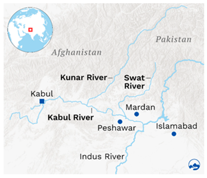
About Kabul River
- The Kabul River, historically known as Cophen, is significant in eastern Afghanistan and the Khyber Pakhtunkhwa province of Pakistan.
Course and Geography
- The Kabul River emerges in the Sanglakh Range of the Hindu Kush Mountains in Maidan Wardak Province, Afghanistan.
- It flows through the cities of Kabul and Jalalabad in Afghanistan, and then enters Khyber Pakhtunkhwa in Pakistan, passing through cities like Peshawar, Charsadda, and Nowshera.
- The river is approximately 700 kilometres (430 miles) long and drains a large basin covering the eastern provinces of Afghanistan.
Hydrology
- The Kabul River is mostly a small trickle throughout the year but swells during summer due to melting snow from the Hindu Kush Range.
- Its major tributaries include the Logar, Panjshir, Alingar, Surkhab, Kunar, Bara, and Swat Rivers.
- The Kunar River, a significant tributary, joins the Kabul River near Jalalabad.
Dams
- Several dams have been constructed on the Kabul River and its tributaries. Notable dams include the Surobi Dam, Naghlu Dam, and Darunta Dam in Afghanistan, and the Warsak Dam in Pakistan.
Must Read Articles:
IMPACT OF CLIMATE CHANGE ON ARAL SEA
Source:
Down To Earth
Wikipedia
Wikipedia
|
PRACTICE QUESTION
Q. Consider the following statements about the Amu Darya River:
1. It was historically known as the Oxus River.
2. It empties into the Aral Sea, although human activity has impacted the sea's size.
3. The Hindu Kush mountains serve as its source.
4. It holds the title of Central Asia's longest river.
How many of the above statements are incorrect?
A) Only one
B) Only two
C) Only three
D) All four
Explanation:
Statement 1 (Correct):
The Amu Darya River was historically known as the Oxus River by the Greeks and Romans, reflecting its significance as a geographical landmark in ancient times.
Statement 2 (Correct):
The Amu Darya traditionally flowed into the Aral Sea, but extensive irrigation projects in the 20th and 21st centuries diverted much of its water. This diversion has significantly contributed to the shrinking of the Aral Sea, reducing it to a fraction of its original size.
Statement 3 (Incorrect):
The Amu Darya River originates in the Pamir Mountains, not the Hindu Kush Mountains. The Panj and Vakhsh rivers, which merge to form the Amu Darya, have their sources in the Pamirs.
Statement 4 (Incorrect):
While the Amu Darya is a significant river in Central Asia, it is not the longest. The longest river in Central Asia is the Syr Darya.
|


