
Copyright infringement not intended
Source: Scientific American
Context
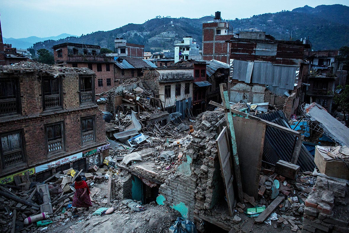
On July 10, 2025, a 4.4 magnitude earthquake struck near Delhi, exposing the city's frail infrastructure.
Why is Delhi prone to earthquakes?
- Delhi is in Seismic Zone IV, which indicates a significant seismic hazard with a peak ground acceleration (PGA) of around 0.24g. For example, similar Zone IV towns such as Srinagar and Patna have already experienced significant tremors.
- Poor Structural Compliance: More than 80% of Delhi's buildings, particularly those built before 2000, do not meet seismic safety requirements. For example, unregulated high-rise flats in East Delhi lack ductile details and shear walls, making them prone to collapse.
- Liquefaction-Prone Areas: The East Delhi and Yamuna floodplains are built on soft alluvial soils that are prone to liquefaction during earthquakes. For example, after the 2001 Bhuj earthquake, structures built on soft soil underwent significant tilting and collapse.
- Rapid Urbanisation: Without Planning: Delhi's urban sprawl and dense population (over 33 million) have resulted in haphazard building, which frequently violates zoning and structural rules.
India’s Seismic Vulnerability: An Overview
- India lies on a tectonic plate that is continuously moving northwards, colliding with the Eurasian Plate at a rate of 4–5 cm per year.
- This movement forms the Himalayas and makes the region highly earthquake-prone, capable of triggering a magnitude 8 or higher earthquake.
- Over 300 million people across northern India, Nepal, and Bhutan are at risk.
Delhi’s Earthquake Risk
- Delhi is located in Seismic Zone IV, a high-risk zone.
- It has a ground acceleration factor of 0.24g, which means the ground can shake violently during an earthquake.
- There are over 5,000 high-rise buildings in Delhi that do not comply with the IS 1893:2016 Code.
- The code demands earthquake-resistant designs, including ductile detailing and shear walls.
- The July 2025 tremors, though moderate, exposed the city’s lack of preparedness among its 33.5 million residents.
Wider Seismic Risk in India
- India’s seismic zones range from Zone II to Zone V, with Zone V being the highest risk.
- Northeastern states like Manipur, Nagaland, and Mizoram fall in Zone V, facing peak ground acceleration of 0.36g or more.
- These regions were affected by:
- A 7.7 magnitude earthquake in Myanmar (March 2025).
- A 5.2 magnitude quake in May 2025.
- The Andaman and Nicobar Islands, also in Zone V, face earthquake and tsunami threats, evident from the 2004 tsunami.
- Even Sikkim experienced tremors from a 5.7 magnitude quake in Tibet on May 12, 2025.
What are the vulnerable areas in India?
|
Vulnerable Area
|
Reason for Vulnerability
|
Examples
|
Seismic Zones
|
|
Himalayan Region
|
Collision of the Indian and Eurasian plates
|
Jammu & Kashmir, Himachal Pradesh, Uttarakhand, Northeast India
|
Zone V
|
|
Indo‑Gangetic Plain
|
Tectonic stress transfer from the Himalayan belt
|
Bihar, Uttar Pradesh, Delhi, West Bengal
|
Zones III & IV
|
|
Peninsular India Fault Zones
|
Reactivation of ancient intraplate faults despite overall geological stability
|
Latur & Koyna (Maharashtra), Bhuj (Gujarat)
|
Zones II – IV (local)
|
What steps has the Indian government taken?
- Building Code Reforms: The government enforces Earthquake-Resistant Building Codes to ensure structural safety in seismic areas. For example, the Bureau of Indian Standards (BIS) changed IS 1893 and IS 4326 to include updated seismic design criteria for various construction industries.
- National Seismic Zoning: India has been divided into seismic risk zones to help guide planning and construction depending on earthquake susceptibility. For example, the country is split into Zones II-V, with Zone V (which includes sections of Uttarakhand and Kashmir) being the most earthquake-prone.
- catastrophe Management Framework: The government has created a specific institutional framework for catastrophe preparedness and response. For example, the National Disaster Management Authority (NDMA) develops earthquake risk reduction guidelines and regularly conducts mock drills and capacity-building programs.
What efforts are being taken at the international level?
- The United Nations adopted the Sendai Framework for Disaster Risk Reduction (2015-2030) to improve disaster preparedness, promote resilient infrastructure, and reduce catastrophic losses. Countries such as Japan and Chile have integrated their national disaster policies with Sendai principles, focusing on risk governance and early warning.
- Global Seismic Hazard Assessment Program (GSHAP): Led by the International Lithosphere Program, this program publishes seismic hazard maps to assist countries in developing safer infrastructure. For example, Italy and other European nations use GSHAP data to alter building rules and zoning laws in earthquake-prone areas.
- Early Warning Systems and Technology Sharing: Countries are working together to develop earthquake early warning systems and share real-time seismic data across borders. Examples include the Pacific Tsunami Warning Center and Japan's Earthquake Early Warning System, which help neighboring countries prepare for seismic events faster.
FAQs
1. What is seismic resilience and why is it important for India?
Seismic resilience refers to a region’s ability to withstand and recover from earthquakes. It's crucial for India as large areas lie in high-risk seismic zones, especially in the Himalayas and Northeast.
2. Which regions in India fall under the highest seismic risk zones?
Regions like Jammu & Kashmir, Himachal Pradesh, Uttarakhand, Northeast India, and the Andaman & Nicobar Islands fall under Seismic Zone V, the most earthquake-prone zone in India.
3. What is the IS 1893:2016 Code and how does it help?
IS 1893:2016 is India’s earthquake-resistant design code. It mandates structural safety measures like ductile detailing and shear walls to reduce building collapse during earthquakes.
4. How does tectonic plate movement contribute to India’s seismic vulnerability?
The Indian Plate moves 4–5 cm per year towards the Eurasian Plate, creating stress that leads to major earthquakes, especially in the Himalayan belt.
5. What steps can improve seismic resilience in Indian cities like Delhi?
Steps include enforcing building codes, retrofitting unsafe structures, conducting earthquake drills, and integrating disaster preparedness in urban planning.
|
Practice Question
Q. Earthquakes along the plate margins are still a cause of concern. India’s preparedness for mitigating their impact has significant gaps. Discuss various aspects.
|
