The Vice-President described river interlinking as vital for India's food and water security, essential for combating water stress, droughts, and increasing irrigation.
ILR refers to the large-scale transfer of water from water-surplus river basins to water-deficit regions through a network of reservoirs, canals, and tunnels.
India possesses 18% of the world's population but only 4% of global freshwater resources, making optimal water distribution critical.
The concept traces back to Sir Arthur Cotton's 19th-century proposals for southern India; revived by Captain Dastur in 1977.
The Supreme Court directed the Centre in 2002 to formulate a concrete plan, leading to accelerated policy momentum.
|
Transfer of Water from Surplus to Deficit Basins Northeastern rivers (Brahmaputra, Barak) and Himalayan tributaries carry excess water during monsoons, causing recurrent floods. Peninsular and western regions face acute water stress; Cauvery basin in Tamil Nadu and Sabarmati basin in Gujarat run perennial deficits. Inter-basin transfer redistributes water geographically rather than temporally (unlike dams that store monsoon water). |
Objectives of River Interlinking
Eradicate Severe Water Scarcity: Distributes freshwater equitably to support over 600 million Indians currently facing high water stress in drought-prone territories.
Mitigate Floods and Droughts: Diverts destructive floodwaters out from vulnerable Northern and Eastern basins directly into the parched Western and Southern states.
Boost Agricultural Productivity: Expands irrigation potential by an additional 35 million hectares, reducing crop failure risks.
Generate Renewable Energy: Harnesses infrastructure to produce approximately 34,000 MW of hydroelectric power, advancing India's renewable energy targets
The Ministry of Irrigation (now Ministry of Jal Shakti) formulated the National Perspective Plan (NPP) in 1980 to execute this vision.
The National Water Development Agency (NWDA) manages the feasibility studies and Detailed Project Reports (DPRs).
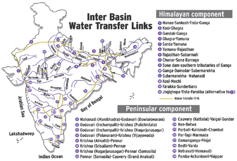
The NRLP functions through two primary components:
In 2005, the government officially added an intra-state component to interconnect regional rivers within individual state boundaries.
|
Major River Linking Projects in India Ken-Betwa Link Project (KBLP): India’s first priority link under implementation. It transfers surplus Ken River water to the Betwa River to rejuvenate the arid Bundelkhand region. The project costs ₹44,605 crore and builds the Daudhan Dam. Godavari-Cauvery Link: Includes the Godavari-Krishna, Krishna-Pennar, and Pennar-Cauvery sub-links. It transfers surplus Godavari water to mitigate severe Southern water deficits. Modified Parbati-Kalisindh-Chambal Link: Integrates seamlessly with the Eastern Rajasthan Canal Project (ERCP) to completely optimize the Chambal River System. Polavaram Irrigation Project: Involves the Godavari-Krishna (Vijayawada) link, currently receiving massive central assistance of ₹20,658 crore to supply irrigation across Andhra Pradesh. |
Political and Administrative
Inter-State Water Disputes: Water remains a state subject under the Constitution; conflicts erupt over sharing formulas (e.g., Kerala-Tamil Nadu tensions).
Central-State Coordination Gaps: Delays in approvals, fund allocation, and consensus-building stall project timelines.
International Complications: Himalayan links affect Nepal, Bhutan, and Bangladesh, requiring complex diplomatic negotiations and transboundary water-sharing treaties.
Environmental and Ecological
Habitat Destruction: KBLP submerges 98 sq. km of Panna Tiger Reserve, threatening tigers, gharials, and endemic biodiversity.
Deforestation at Scale: Major projects may fell trees across 50,000 hectares, altering microclimates and carbon sinks.
Hydrological Disruption: Recent studies warn that inter-basin transfers may reduce rainfall in donor basins, triggering unintended climatic consequences.
Economic and Social
Massive Capital Outlay: Total NRLP cost may exceed ₹5 lakh crore; individual projects like KBLP cost ₹44,605 crore.
Questionable Cost-Benefit Ratios: Some links show benefit-to-cost ratios below 1, raising viability concerns.
Displacement Crisis: Thousands of families face forced relocation; KBLP alone may displace over 20,000 people.
Livelihood Disruption: Farmers, fishers, and forest-dependent communities lose income sources without adequate rehabilitation.
Compensation Delays: Poor resettlement planning triggers local protests and judicial interventions.
|
Government Safeguards Mandatory Environmental Impact Assessments (EIA): Evaluates physical, biological, and socio-economic risks before granting any statutory or wildlife clearances. Special Purpose Vehicles (SPVs): Operates dedicated institutional bodies like the Ken Betwa Link Project Authority (KBLPA) to ensure highly transparent fund utilization. Integrated Landscape Management Plan (ILMP): Protects crucial biodiversity and wildlife corridors. The Greater Panna Landscape Council (GPLC) enforces this plan systematically. Fair Compensation Frameworks: Executes land acquisition strictly under the Right to Fair Compensation and Transparency in Land Acquisition, Rehabilitation and Resettlement Act, 2013 (RFCTLAR Act). Phased Implementation: Government adopts gradual rollout to minimize simultaneous social and ecological shocks. |
Strengthen Inter-State Cooperation: Establish permanent river basin authorities with binding arbitration powers to resolve disputes proactively.
Encourage Cooperative Federalism: Utilize Article 262 effectively to settle inter-state disputes. Establish the Single Permanent Tribunal and Dispute Resolution Committee to resolve conflicts within strict timeframes.
Integrate Local Conservation: Combine heavy infrastructure with decentralized micro-strategies like the "Jal Sanchay Jan Bhagidari" initiative to holistically recharge groundwater.
Implement Phased Execution: Roll out the 30 identified links progressively to thoroughly monitor environmental feedback and prevent immediate socio-economic shocks.
Prioritize Ecological Restoration: Commit to massive compensatory afforestation and execute scientifically backed species recovery plans to offset the inevitable loss of local habitats.
Diversify Water Strategy: Combine interlinking with rainwater harvesting, aquifer recharge, and desalination plants for coastal states.
Build Public Consensus: Conduct transparent consultations with farmers, tribal communities, and environmental groups before ground-breaking.
Learn From Global Experience
Rhine-Main-Danube Canal (Europe): Demonstrates how inland waterways successfully substitute road transport, cutting logistics costs and reducing the carbon footprint.
Illinois Waterway (USA): Proves that engineered inter-basin channels flawlessly provide industrial and municipal water while maintaining heavy commercial navigation.
Murray-Darling Basin (Australia): Serves as a warning. Heavy engineering alterations to natural seasonal flows triggered severe soil salinity, cyanobacteria blooms, and catastrophic ecological collapse, proving the absolute necessity of environmental caution.
Netherlands' Delta Works: The Dutch model proves that integrated water management combining engineering with ecological restoration yields sustainable flood protection.
Thailand's Chao Phraya Management: Thailand demonstrates that participatory governance involving local communities prevents conflict and ensures equitable distribution.
Conclusion
River interlinking can strengthen India's water security and climate resilience, provided ecological sustainability, social justice, and scientific planning remain central to implementation.
Source: pib
|
PRACTICE QUESTION Q. River interlinking is increasingly viewed as a solution to India's water security challenges. Critically examine its potential and limitations. (250 Words) |
River interlinking is a large-scale engineering concept that connects distinct rivers using network canals and reservoirs to transfer surplus water from flood-prone basins to water-scarce regions.
The National River Linking Programme is a massive country-wide water infrastructure master plan designed to link 37 Himalayan and Peninsular rivers to systematically balance India's highly uneven seasonal water distribution.
The infrastructure delivers massive multi-purpose dividends by irrigating millions of hectares of parched farmlands, generating clean hydroelectric power, creating inland navigation channels, and securing domestic drinking water.
The National Water Development Agency (NWDA), functioning under the Union Ministry of Jal Shakti, serves as the apex body responsible for investigating, planning, and executing all inter-basin water transfer links.
© 2026 iasgyan. All right reserved
