Just as different seats in a play (theater) provide different perspectives on a performance, different Earth orbits give satellites varying perspectives, each valuable for different reasons. Some seem to hover over a single spot, providing a constant view of one face of the Earth, while others circle the planet, zipping over many different places in a day.
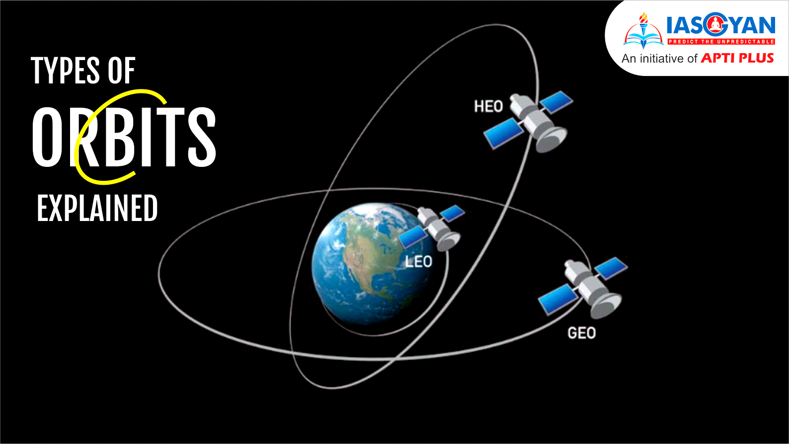
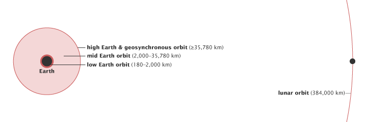
There are essentially three types of Earth orbits: high Earth orbit, medium Earth orbit, and low Earth orbit. Many weather and some communications satellites tend to have a high Earth orbit, farthest away from the surface. Satellites that orbit in a medium (mid) Earth orbit include navigation and specialty satellites, designed to monitor a particular region. Most scientific satellites, including NASA’s Earth Observing System fleet, have a low Earth orbit.
Before we delve deeper into the various types of orbits, let us learn about the various factors that affect a satellite’s movement. These very factors determine the type of an orbit and the view a satellite on a particular orbit will have of Earth.
The higher a satellite’s orbit, the slower it moves.
The height of the orbit, or distance between the satellite and Earth’s surface, determines how quickly the satellite moves around the Earth. An Earth-orbiting satellite’s motion is mostly controlled by Earth’s gravity. As satellites get closer to Earth, the pull of gravity gets stronger, and the satellite moves more quickly.
Changing a satellite’s height will also change its orbital speed. This introduces a strange paradox. If a satellite operator wants to increase the satellite’s orbital speed, he can’t simply fire the thrusters to accelerate the satellite. Doing so would boost the orbit (increase the altitude), which would slow the orbital speed. Instead, he must fire the thrusters in a direction opposite to the satellite’s forward motion. This change will push the satellite into a lower orbit, which will increase its forward velocity.
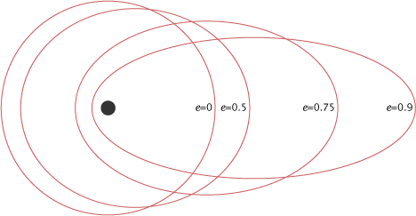
Eccentricity refers to the shape of the orbit. A satellite with a low eccentricity orbit moves in a near circle around the Earth. An eccentric orbit is elliptical, with the satellite’s distance from Earth changing depending on where it is in its orbit.
|
The eccentricity (e) of an orbit indicates the deviation of the orbit from a perfect circle. A circular orbit has an eccentricity of 0, while a highly eccentric orbit is closer to (but always less than) 1. A satellite in an eccentric orbit moves around one of the ellipse’s focal points, not the center. |
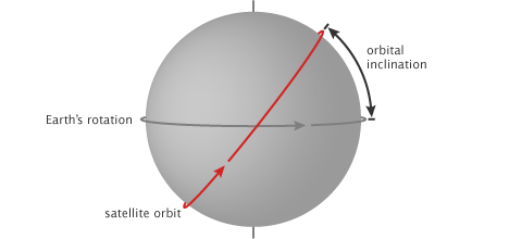
Inclination is the angle of the orbit in relation to Earth’s equator. A satellite that orbits directly above the equator has zero inclination. If a satellite orbits from the north pole (geographic, not magnetic) to the south pole, its inclination is 90 degrees.
|
Orbital inclination is the angle between the plane of an orbit and the equator. An orbital inclination of 0° is directly above the equator, 90° crosses right above the pole, and 180° orbits above the equator in the opposite direction of Earth’s spin. |
Together, the satellite’s height, eccentricity, and inclination determine the satellite’s path and what view it will have of the Earth.
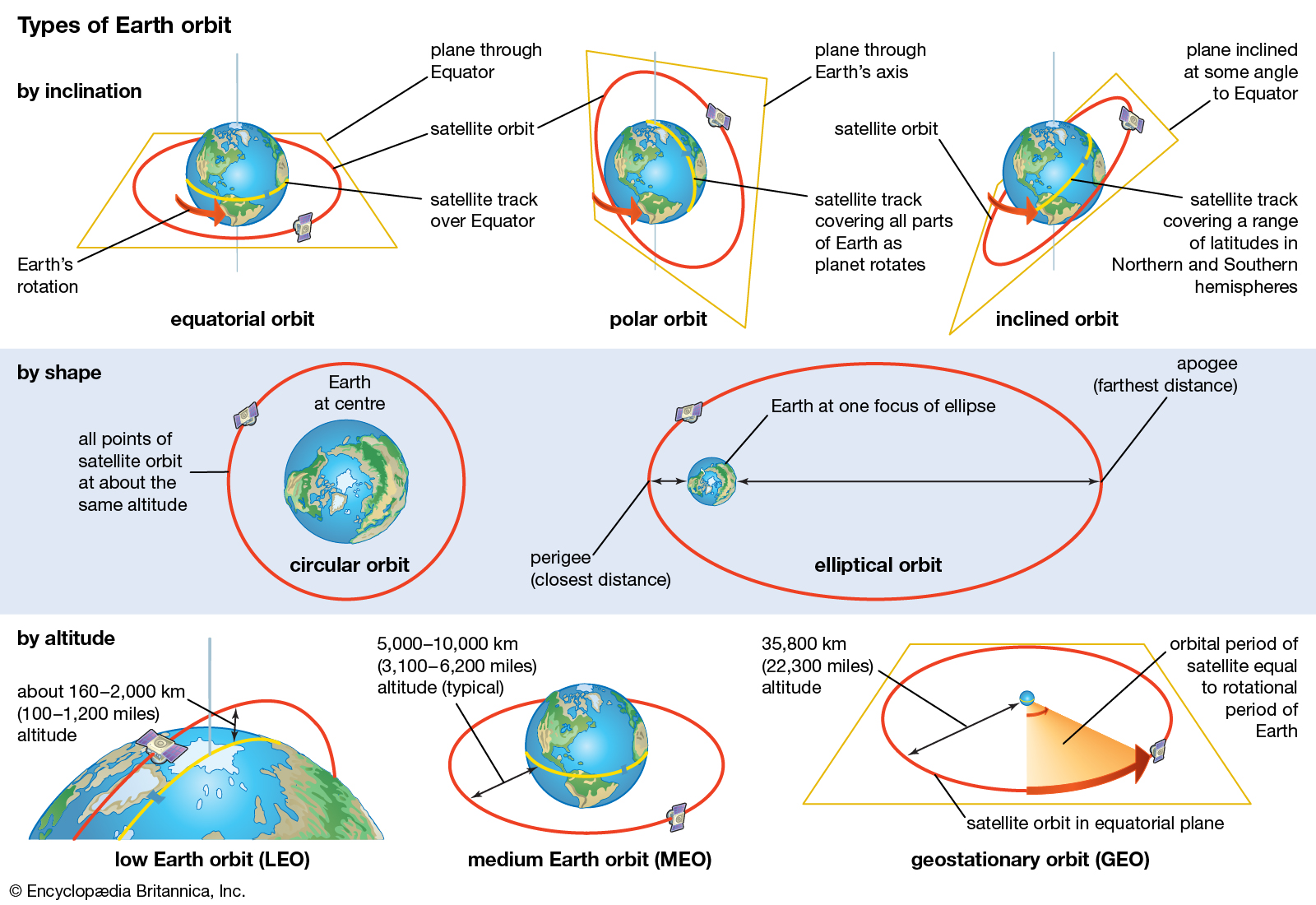
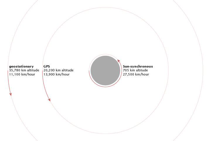
When a satellite reaches exactly 42,164 kilometers from the center of the Earth (about 36,000 kilometers from Earth’s surface), it enters a sort of “sweet spot” in which its orbit matches Earth’s rotation. Because the satellite orbits at the same speed that the Earth is turning, the satellite seems to stay in place over a single longitude, though it may drift north to south. This special, high Earth orbit is called geosynchronous.
A satellite in a circular geosynchronous orbit directly over the equator (eccentricity and inclination at zero) will have a geostationary orbit that does not move at all relative to the ground. It is always directly over the same place on the Earth’s surface.
Weather Monitoring
A geostationary orbit is extremely valuable for weather monitoring because satellites in this orbit provide a constant view of the same surface area. When you visit Google Maps and look at the satellite view of your hometown, the image you are seeing comes from a satellite in geostationary orbit.
Every few minutes, geostationary satellites like the Geostationary Operational Environmental Satellite (GOES) satellites send information about clouds, water vapor, and wind, and this near-constant stream of information serves as the basis for most weather monitoring and forecasting.
Communication
Because geostationary satellites are always over a single location, they can also be useful for communication (phones, television, radio).
Example: They provide a search and rescue beacon used to help locate ships and airplanes in distress.
Solar Activity
Finally, many high Earth orbiting satellites monitor solar activity. They carry a large contingent of “space weather” instruments that take images of the Sun and track magnetic and radiation levels in space around them.
|
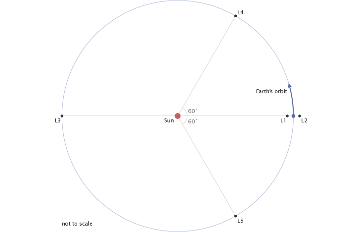
Lagrange Points – Spots beyond the High Earth Orbits Other orbital “sweet spots,” just beyond high Earth orbit, are the Lagrange points. At the Lagrange points, the pull of gravity from the Earth cancels out the pull of gravity from the Sun. Anything placed at these points will feel equally pulled toward the Earth and the Sun and will revolve with the Earth around the Sun.
Of the five Lagrange points in the Sun-Earth system, only the last two, called L4 and L5, are stable. A satellite at the other three points is like a ball balanced at the peak of a steep hill: any slight perturbation will push the satellite out of the Lagrange point like the ball rolling down the hill. Satellites at these three points need constant adjustments to stay balanced and in place.
L-1 The first Lagrange point is located between the Earth and the Sun, giving satellites at this point a constant view of the Sun. The Solar and Heliospheric Observatory (SOHO), a NASA and European Space Agency satellite tasked to monitor the Sun, orbits the first Lagrange point, about 1.5 million kilometers away from Earth.
L-2 The second Lagrange point is about the same distance from the Earth, but is located behind the Earth. Earth is always between the second Lagrange point and the Sun. Since the Sun and Earth are in a single line, satellites at this location only need one heat shield to block heat and light from the Sun and Earth. It is a good location for space telescopes, including the future James Webb Space Telescope (Hubble’s successor, scheduled to launch in 2014) and the current Wilkinson Microwave Anisotropy Probe (WMAP), used for studying the nature of the universe by mapping background microwave radiation. L-3 The third Lagrange point is opposite the Earth on the other side of the Sun so that the Sun is always between it and Earth. A satellite in this position would not be able to communicate with Earth. The extremely stable fourth and fifth Lagrange points are in Earth’s orbital path around the Sun, 60 degrees ahead of and behind Earth. The twin Solar Terrestrial Relations Observatory (STEREO) spacecraft will orbit at the fourth and fifth Lagrange points to provide a three-dimensional view of the Sun.
Lagrange points are special locations where a satellite will stay stationary relative to the Earth as the satellite and the Earth revolve around the Sun. L1 and L2 are positioned above the day and night sides of the Earth, respectively. L3 is on the other side of the Sun, opposite the Earth. L4 and L5 are 60° ahead and behind the Earth in the same orbit. |

Closer to the Earth, satellites in a medium Earth orbit move more quickly. The orbit is home to a number of artificial satellites – the most common uses include navigation, communication, and geodetic/space environment science. Two medium Earth orbits are notable: the semi-synchronous orbit and the Molniya orbit.
Semi-Synchronous Orbit
The semi-synchronous orbit is a near-circular orbit (low eccentricity) 26,560 kilometers from the center of the Earth (about 20,200 kilometers above the surface). A satellite at this height takes 12 hours to complete an orbit. As the satellite moves, the Earth rotates underneath it. In 24-hours, the satellite crosses over the same two spots on the equator every day. This orbit is consistent and highly predictable. It is the orbit used by the Global Positioning System (GPS) satellites.
Molniya orbit
The second common medium Earth orbit is the Molniya orbit. The Molniya orbit works well for observing high latitudes. A geostationary orbit is valuable for the constant view it provides, but satellites in a geostationary orbit are parked over the equator, so they don’t work well for far northern or southern locations, which are always on the edge of view for a geostationary satellite. The Molniya orbit offers a useful alternative.
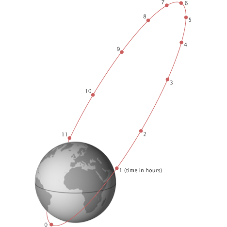
The Molniya orbit is highly eccentric: the satellite moves in an extreme ellipse with the Earth close to one edge. Because it is accelerated by our planet’s gravity, the satellite moves very quickly when it is close to the Earth. As it moves away, its speed slows, so it spends more time at the top of its orbit farthest from the Earth. A satellite in a Molniya orbit takes 12 hours to complete its orbit, but it spends about two-thirds of that time over one hemisphere. Like a semi-synchronous orbit, a satellite in the Molniya orbit passes over the same path every 24 hours. This type of orbit is useful for communications in the far north or south.
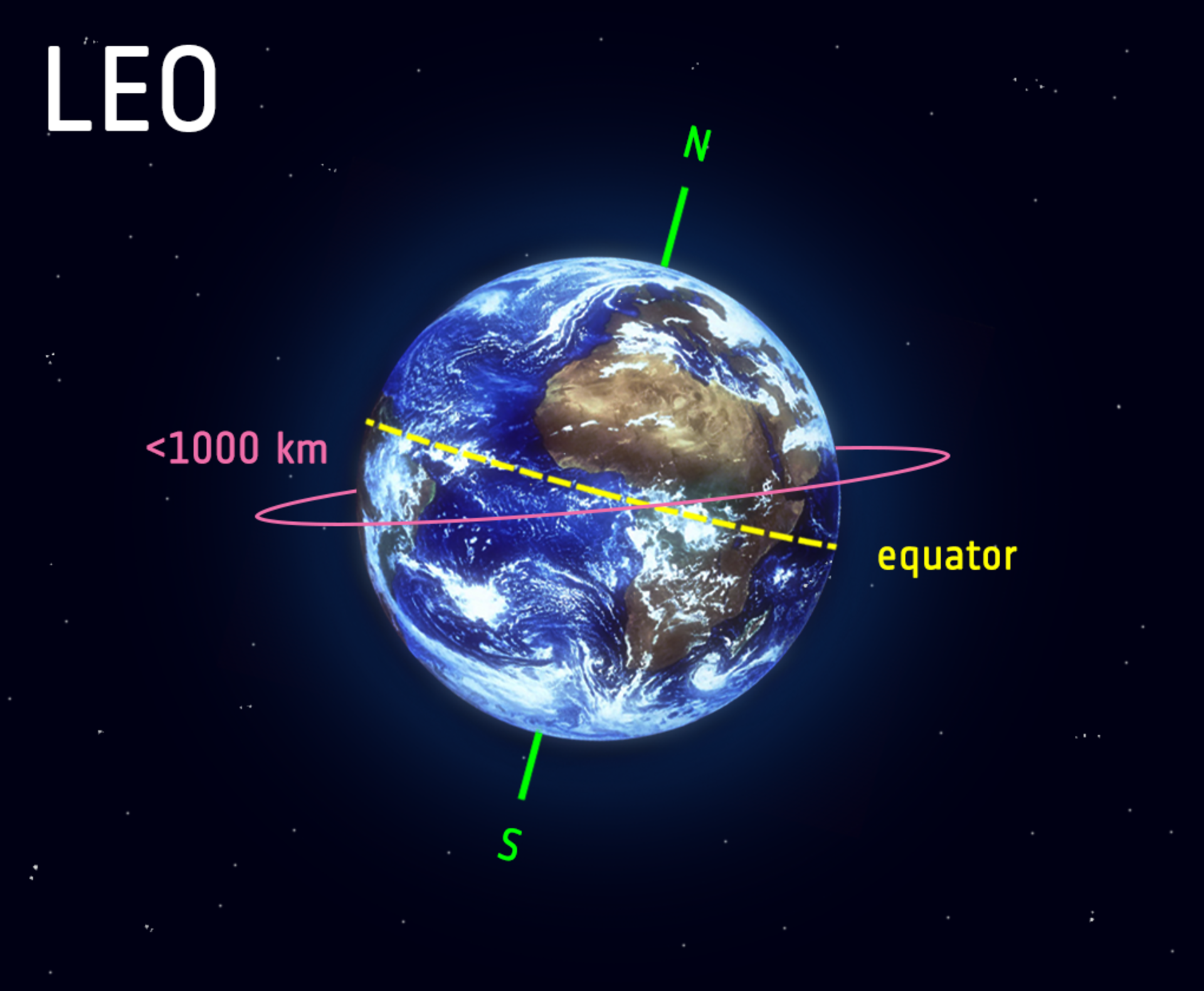
A low Earth orbit (LEO) is, as the name suggests, an orbit that is relatively close to Earth’s surface. It is normally at an altitude of less than 1000 km but could be as low as 160 km above Earth.
By comparison, most commercial aeroplanes do not fly at altitudes much greater than approximately 14 km, so even the lowest LEO is more than ten times higher than that.
Unlike satellites in Geostationary Orbits that must always orbit along Earth’s equator, LEO satellites do not always have to follow a particular path around Earth in the same way – their plane can be tilted. This means there are more available routes for satellites in LEO, which is one of the reasons why LEO is a very commonly used orbit.
LEO’s close proximity to Earth makes it useful for several reasons.
Functions
Satellite Imaging
It is the orbit most commonly used for satellite imaging, as being near the surface allows it to take images of higher resolution.
ISS
It is also the orbit used for the International Space Station (ISS), as it is easier for astronauts to travel to and from it at a shorter distance. Satellites in this orbit travel at a speed of around 7.8 km per second; at this speed, a satellite takes approximately 90 minutes to circle Earth, meaning the ISS travels around Earth about 16 times a day.
However, individual LEO satellites are less useful for tasks such as telecommunication, because they move so fast across the sky and therefore require a lot of effort to track from ground stations.
Instead, communications satellites in LEO often work as part of a large combination or constellation, of multiple satellites to give constant coverage. In order to increase coverage, sometimes constellations like this, consisting of several of the same or similar satellites, are launched together to create a ‘net’ around Earth. This lets them cover large areas of Earth simultaneously by working together.
Polar Orbit: A subtype of LEO
Satellites in polar orbits usually travel past Earth from north to south rather than from west to east, passing roughly over Earth's poles.
Satellites in a polar orbit do not have to pass the North and South Pole precisely; even a deviation within 20 to 30 degrees is still classed as a polar orbit. Polar orbits are a type of low Earth orbit, as they are at low altitudes between 200 to 1000 km.
Sun-synchronous orbit (SSO) – A further subtype of Polar Orbit
Sun-synchronous orbit (SSO) is a particular kind of polar orbit. Satellites in SSO, travelling over the polar regions, are synchronous with the Sun. This means they are synchronised to always be in the same ‘fixed’ position relative to the Sun. This means that the satellite always visits the same spot at the same local time – for example, passing the city of Paris every day at noon exactly.
More technically, it is an orbit arranged so that it precesses through one complete revolution each year, so it always maintains the same relationship with the Sun. A Sun-synchronous orbit is useful for imaging, spy, and weather satellites.
As the satellite will always observe a point on the Earth as if constantly at the same time of the day, it serves a number of applications; for example, it means that scientists and those who use the satellite images can compare how somewhere changes over time.
This is because, if you want to monitor an area by taking a series of images of a certain place across many days, weeks, months, or even years, then it would not be very helpful to compare somewhere at midnight and then at midday – you need to take each picture as similarly as the previous picture as possible. Therefore, scientists use image series like these to investigate how weather patterns emerge, to help predict weather or storms; when monitoring emergencies like forest fires or flooding; or to accumulate data on long-term problems like deforestation or rising sea levels.
A satellite in a Sun-synchronous orbit would usually be at an altitude of between 600 to 800 km. At 800 km, it will be travelling at a speed of approximately 7.5 km per second.
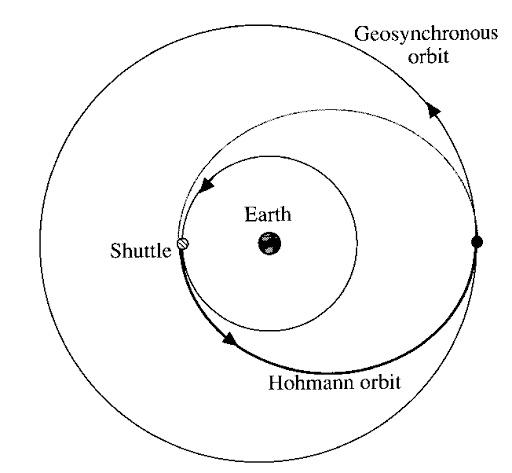
Transfer OrbitTransfer orbits are a special kind of orbit used to get from one orbit to another. When satellites are launched from Earth and carried to space with launch vehicles, the satellites are not always placed directly on their final orbit. Often, the satellites are instead placed on a transfer orbit: an orbit where, by using relatively little energy from built-in motors, the satellite or spacecraft can move from one orbit to another.
This allows a satellite to reach, for example, a high-altitude orbit without actually needing the launch vehicle to go all the way to this altitude, which would require more effort. So, this is like taking a shortcut.
Example: Satellites which are destined for geosynchronous (GSO) or geostationary orbit (GEO) are (almost) always put into a Geostationary Transfer Orbit (GTO) as an intermediate step for reaching their final orbit.
A GTO is highly elliptic. Its perigee (closest point to Earth) is typically as high as low Earth orbit (LEO), while its apogee (furthest point from Earth) is as high as geostationary (or equally, a geosynchronous) orbit. It’s called Hohmann transfer orbit that lies between Low Earth Orbit and Geosynchronous Orbit.
|

© 2026 iasgyan. All right reserved